South Yorkshire Times, Friday, December 30th, 1932
Wombwell’s Hidden Beauty
The Waterfall at Broomhill
A Fragment of Railway History
Walking the bounds of the parish or township was a custom which in olden days used on conscientiously and jealously to be attended to.
The custom was observed annually when a procession was formed and churchwardens, overseers and all the lesser functionaries of local government used to walk the boundaries in ceremonial fashion, placing landmarks in different places where there was any possibility of a despute arising between ye Smiths and ye Browns. In an old account related to this district is the following entry:
”1793 paid at ye perambulating or going about ye boundaries, £0 15s 4d”
The accuracy of modern surveys had rendered these picturesque old world observations useless and obsolete; maps are now available for verification; disputes regarding parish boundaries seldom arise. From the standpoint of general information, however, there appears to be justification for a revival of this ancient and picturesque custom; members of local authorities would obviously be better equipped for their duties if they knew all there is to know about the topography of the area they represent. Ditches and waterways were not unimportant factors.
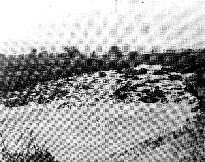
Broomhill Waterfall
Continuing our series of hidden beauties on the boundaries of Wombwell we reproduce herewith a snap taken of the Inge at Broomhill. This lovely waterfall occurs where the river Dearne, winding placidly through the lowlands between Darfield and Bolton, is diverted by the London, Midland and Scottish main line running south from Leeds to Sheffield via Darfield. The landscape in this particular district has nothing of the rugged grandeur that contributes to the beauty of the scenery at the Dovecliffe end of the township, but in this little cameo there are many elements that go to make an artist’s picture.
With the sunlight playing on the water the prospect is an unusually attractive one—for Wombwell. Strange it is that the waterfall occurs within fifty yards of a public footpath probably not more than one in every hundred of Wombwell residents have either seen it or are aware of its existence. It is worth going out of one’s way to look upon.
The question of this waterfall and its effect upon inundation cropped up at a meeting of the Darfield Urban District Council recently. Mr. John Brass, general manager and director of Houghton Main Collieries, suggested that if the weir were removed the flooding of the meadows between Wombwell and Darfield and Cudworth and Little Houghton would be obviated. There may be a good deal in it.
When was the weir constructed and for what purpose? No one seemed to know, but the Council undertook to make investigations.
River Diversion.
As a matter of fact the weir constructed as part of a scheme of deviation and was put into the bed of the river exactly one hundred years ago. At one time the river took a natural winding course in and mound Bolton Ings, but when the railway was constructed in the early part of last century numerous bends were taken out and the length of the water course was shortened considerably. By keeping the river at the other side of the permanent way the railway engineers avoided the cost of the construction of many bridges and also, incidentally, the cost of perpetual maintenance.
But the diversion did something else. It had the effect of accelerating the flow of the river to such an extent – that there was danger of the meadows in the upper reaches at Darfield and Cudworth being denuded of water! It was to hold the water back and as a sort of compensation for the effect of deviation the weir was constructed. That occurred before the days of colliery subsidence and the question as to whether the removal of this weir would not obviate the modern nuisance of inundation becomes a thoroughbly sensible and practical one. Anyway the idea is well worth investigation. Observers will notice that at this point the river now takes an absolutely straight course tor a distance of about a mile.
But the town boundaries were like the laws of the Medes and Persians in that they altered not. For local administrative purposes the old course of the river still determines the town boundary and it will probably surprise many to learn that there is a large slice of Wombwell on the Billingley side of the railway; for instance the old fox covert on Billingley Ings is actually in Wombwell.
Another interesting feature of local geography that will probably astonish many is the fact that the limit of Wombwell’s jurisdiction extends some twelve hundred yards on the Wath side of this waterfall and reaches very near to the sidings of Wath Main Colliery. ‘That is the point where the river Dearne and the Knoll Beck converge.
A Railway Pioneer.
It is a point not unworthy of mention that when the main line linking London with Scotland, and superseding the stage coach, was comprehended. Wombwell (or at least a small corner of it) was included in the great scheme; and another point of note is that one of the master-brains of this great engineering work was a Worsboro’ man, William Shaw. The Shaw family lived at Worsboro’ for many generations, and it was the father of the engineer who, being a stone mason by trade, erected the “Mason’s Arms” at Worsboro’ in the year 1806. William Shaw junr. was then two years old. After his education at the village school William took up his father’s trade and when only ten years of age was engaged in the erection of St. George’s Church, Barnsley, being left solely in charge of the work three years later. He was subsequently engaged in the construction of many canals and his long connection with railway works commenced on the Leeds to Selby him in 1830. In 1838 he was appointed to construct a portion of the line here mentioned (including the well-known Chevet tunnel) and took up residence at Wakefield. Amassing great wealth by his engineering genius Shaw contributed half the cost of erecting one of the most notable buildings in Barnsley—the Congregational Church.
Within living memory the tunnel at Cat Hill near this waterfall was opened out and Darfield station was removed from Broomhill to its present position. One of the best authorities on the history of this little peninsula is Mr. Joseph Brooke, of Old Moor Farm, to whom the land belongs. At one time famous for the breeding and training of thoroughbred horses, this site has recently been recommended as a suitable place for an aviation landing ground. It was used as such during the Great War.